
Geo-World Home
Seismology Home
Plate Tectonics
Earthquake!
«Asian Earthquake
San Francisco Earthquake
Teachers

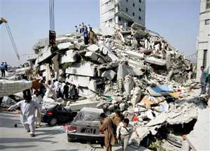
A SPECIAL REPORT ON THE EARTHQUAKE IN PAKISTAN
 What caused the Earthquake in Pakistan?
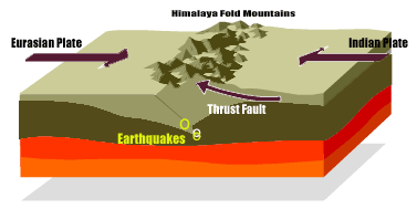
Earthquakes and active faults in northern Pakistan and adjacent parts of India and Afghanistan are the direct result of the Indian subcontinent moving northward at a rate of about 40 mm/yr (1.6 inches/yr) and colliding with the Eurasian continent.
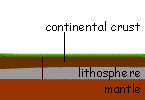 This collision is causing uplift that produces the highest mountain peaks in the world including the Himalayan, the Karakoram, the Pamir and the Hindu Kush ranges. As the Indian plate moves northward, it is being subducted or pushed beneath the Eurasian plate. Much of the compressional (squeezing together) motion between these two colliding plates has been and continues to be accommodated by slip on a suite of major thrust faults that are at the Earth’s surface in the foothills of the mountains and dip northward beneath the ranges.
These include the Main Frontal thrust, the Main Central thrust, the Main boundary thrust, and the Main Mantle thrust. These thrust faults have a sinuous trace as they arc across the foothills in northern India and into northern Pakistan. Near the town of Muzaffarabad, about 10 km southwest of the earthquake epicenter, active thrust faults that strike northwest-southeast have deformed and warped Pleistocene alluvial-fan surfaces into anticlinal ridges. The strike and dip direction of these thrust faults is compatible with the style of faulting indicated by the focal mechanism from the nearby M 7.6 earthquake.
 Will there be more Earthquakes?
The short anser is yes. There have already been many aftershocks (the strongest of which was 6.2 on the Richter Scale). Click here to view where the quake occurred and wherethe after shocks have been. These can be very dangerous for already weakened structures.