
Don't forget to use the rest of the geo-world portal to examine earthquakes, volcanoes, climatic hazards and more.
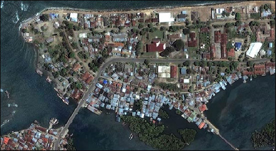
Above: Rollover the image to see before and after photographs taken by satellite of part of Banda Aceh, the nearest large settlement in Indonesia and the one most affected by the Tsunami in terms of the ammount of people who died:
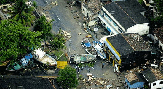
Above: Boats brought inland by the tsunami in Sri Lanka

A street littered with vehicles and other debris near Patong Beach in Phuket, on the western coast.
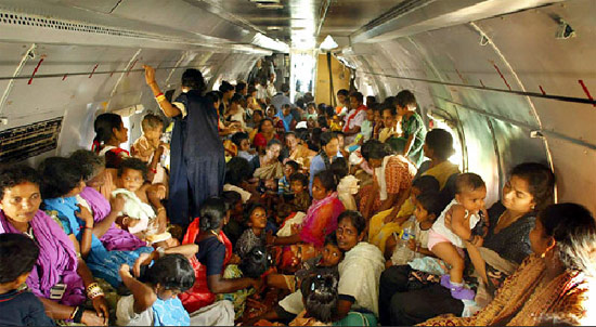
Above: Women and children evacuated on a plane in India.
Photo Credits: New York Times Go to this website to see more
Did you know: The ocean often recedes away from shore just before a tsunami wave hits land?
 Reason: Although tsunamis are commonly depicted as a giant breaking wave with a crest towering over the land, this image is hardly, if ever, the case. Instead tsunamis can more accurately be described as a rapidly-rising tide without a developed wave face, which quickly and forcefully floods low-lying coastal areas.
Ironically, in deep, open-ocean water, tsunami waves are often less than a meter high and can travel at speeds up to 1,000 kilometers per hour (621 mph). However, as a tsunami wave approaches shallower waters along the coast, the leading edge of the wave begins to slow down while the rest of the wave begins to “pile up” behind it—causing it to grow in height while maintaining its strength. The crest of this wave can be several meters high by the time it reaches the shoreline. Sometimes, however, the crest of the wave isn’t the first to arrive—the trough is. This is often the case when the tsunami originates from an oceanic earthquake associated with land subsidence or sinking, which causes the water column to drop down at the earthquake site. In this case, instead of extremely high water levels, the first sign of a tsunami is what appears to be an unusually low-tide. Although onlookers might be intrigued by this unusual site, this major withdrawal of the sea should be taken as a warning that a tsunami wave will soon follow.
Could you have saved anyone from the Tsunami?
LONDON (Reuters) - A 10-year-old British girl saved 100 other tourists from the Asian tsunami having warned them a giant mass of water was on its way after learning about the phenomenon weeks earlier at school.
"I was on the beach and the water started to go funny," Tilly Smith told the Sun at the weekend from Phuket, Thailand.
"There were bubbles and the tide went out all of a sudden. I recognised what was happening and had a feeling there was going to be a tsunami. I told mummy."
While other holidaymakers stood and stared as the disappearing waters left boats and fish stranded on the sands, Tilly recognised the danger signs because she had done a school project on giant waves caused by underwater earthquakes.
Quick action by Tilly's mother and Thai hotel staff meant Maikhao beach was quickly cleared, just minutes before a huge wave crashed ashore. The beach was one of the few on the Thai island of Phuket where no-one was killed.
Her teacher, Andrew Kearney, paid tribute to his quick-thinking student.
"Tilly is a very bright, level-headed girl ... it is an incredible coincidence that our class were learning about this type of tsunami just two weeks before Christmas," he told the newspaper.
Source: yahoo news
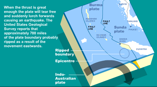
If the fault ruptured for 15ookm where exactly was the epicentre?
For very large events, this is just the beginning of the rupture process and the place from which the
very first waves emanate. In the case of the Sumatra event, the rupture expanded to the north along the plate boundary, eventually involving more than 1,200 km. A typical rupture velocity is 3 km/s, so it would have taken at least 400 s (more than 6 1/2 minutes) for the most northern limit to start rupturing. Seismic waves
are radiated from all of the portions of the fault that are rupturing.
Picture a piece of paper that is stretched rapidly until it rips in two. The tear will not occur everywhere simultaneously, but will usually start at one edge of the paper and propagate rapidly across the paper. Once the paper starts tearing at one point, the stress becomes very high at the neighboring un-torn location, which rips next... and so forth across the paper.
In a similar way, once a fault zone starts rupturing, the adjacent portion ofthe fault zone becomes rapidly stressed, slips, and so forth as the rupture propagates, usually at about 80% of the S-wave velocity.
Below are a series of graphics fromThe Guardian and BBC websites which show how the tsunami was triggered. NEW- Click here to see animation of wave progress
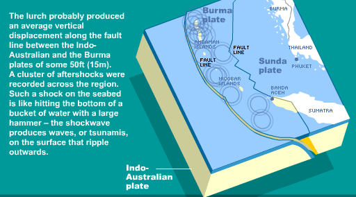
Which explains the tectonic forces that caused the initial eathquake and triggered the tsunami. The diagrams below taken from the BBC website show how the tsunami formed:
This image shows how energy from the earthquake caused a vertical movement of the crust (a jolt of up to 15 metres in places) which displaced hundereds of cubic kilometres of water.
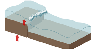
 This graphic shows the start of the wave as it moves outwards from the epicentre of the earthquake at speeds of up to 500 miles an hour in deep water. The wave also reaches down to the sea bed, which does not occur with normal waves.
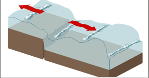
 As it nears the shoreline the wave is slowed down to 50-60mph by friction with the shallower sea bed, but the height of the wave increases substantially, and waht may have been 1-2m high out at sea, can become 10m high (30ft) on the beach. This is why tidal waves are hard to spot until they near land, in which case it is often too late to do anything.
NEW! How to survive hazards when you are on holiday! Great site with useful information prsented in a fun way! Click here now to visit!
Tsunami - One Year on - This new mini-site explores the causes of the earthquake and tsunami using a mixture of film and animation and includes lesson plans and resources for teachers! Click here for more.
The Asian Tsunami is now known to have claimed over 275,000 lives, in one of the worst natural disasters in human history. This website is aimed at helping secondary school children understand the processes that caused the tsunami and thereby understand more about geo-hazards.
The quake was initially reported as 6.8 on the Richter scale. However, on the moment magnitude scale, which is more accurate for quakes of this size, the earthquake's magnitude was first reported as 8.1 by the United States Geological Survey, but after further analysis they increased this first to 8.5 and 8.9 and finally 9.0.
Since 1900, the only earthquakes recorded with a greater magnitude were the 1960 Great Chilean Earthquake (magnitude 9.5) and two Alaskan quakes: the 1964 Good Friday Earthquake in Prince William Sound (9.2) and a March 9, 1957 quake in the Andreanof Islands (9.1). The only other recorded earthquake of magnitude 9.0 was in 1952 off the southeast coast of Kamchatka . Each of these megathrust earthquakes also spawned tsunamis (in the Pacific Ocean), but the death toll from these was significantly lower, ranging from zero to a few thousand.
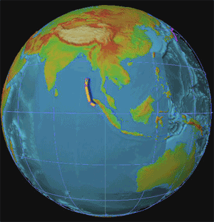
Above: Map of tectonic plates where the earthquake triggered the tsunami.
Image Credit: New York Times
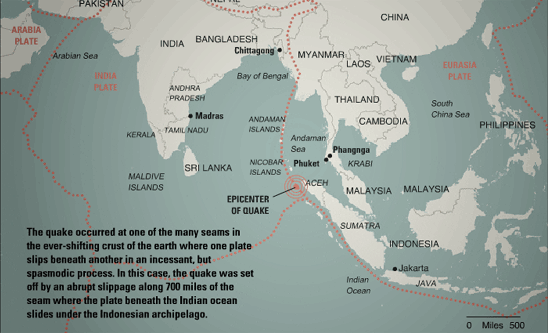
The hypocentre was at 3.316°N, 95.855°E, some 160 km (100 mi) west of Sumatra, at a depth of 30 km (18.6 mi) below mean sea level (initially reported as 10 km). This is at the extreme western end of the "Ring of Fire", an earthquake belt that accounts for 81% of the world's largest earthquakes . The quake itself (apart from the tsunamis) was felt as far away as Bangladesh, India, Malaysia, Myanmar, Singapore, Thailand and the Maldives.
Click on the buttons above to find out more.
 Tsunami is Japanaese for 'wave in the harbour' are caused by large disturbances on the sea bed such as an earthquake, underwater landslides or an underwater volcano erupting. The tsunami in Asia was triggered by a massive earthquake which measured 9.0 on the Richter scale and was more powerful than all of the earthquakes that have occurred in the last year put together.
It was so powerful that it caused the earth to wobble on its axis and the ground was momentarily deformed here in the UK by about 1mm as the earthquake wave passed through. Our school seismograph recorded the event:
»click here to see a small movie of the earthquake as it came in on the seismograph
This undersea megathrust earthquake struck at 00:58:53 UTC (07:58:53 local time) in the Indian Ocean off the western coast of northern Sumatra, Indonesia. It was the largest earthquake on Earth since the 9.2-magnitude Good Friday Earthquake which struck the U.S. state of Alaska in 1964, and tied for fourth largest since 1900.
Image Credit (above right): NOAA - The progress of the wave across the ocean
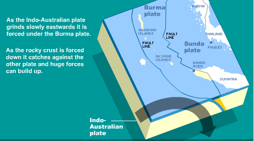
The earthquake was unusually large in geographical extent. An estimated 1,200 km (750 mi) of faultline slipped 20 m (60 ft) along the subduction zone where the India Plate dives under the Burma Plate. The seabed of the Burma plate is estimated to have risen several metres vertically up over the India plate, creating shock waves in the Indian Ocean that traveled at up to 800 km/h (500 mi/h), forming tsunamis when they reached land.
The India Plate is part of the great Indo-Australian Plate, which underlies the Indian Ocean and Bay of Bengal, and is drifting northeast at an average of 6 cm/yr (2 in/yr) (or 20 m (60 ft) per 330 years; i.e. this earthquake moved this fault 330 years worth), relative to the Burma Plate. The Burma Plate carries the Nicobar and Andaman Islands and northern Sumatra, and is pushed by the Sunda Plate to its east. Both the Burma and Sunda Plates are considered portions of the great Eurasian Plate. The tectonic activity that results as these plates scrape against each other led to the creation of the Sunda Arc.
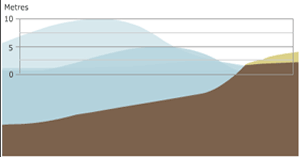
The epicentre of the earthquake was 155 miles from Banda Aceh, off the west coast of northern Sumatra, Indonesia but within hours had affected millions of people living along coastlines facing the Indian ocean. The graphics below show how high the wave was as it arrived at different places around the Indian Ocean:
 |
 |
 |
